
Research & Development
Certified Drone Pilots Ltd is developing CDP ORBIT VERIFY, an Earth Observation-enabled R&D concept exploring how organisations managing land and development sites can determine when additional site evidence is genuinely required - and what minimum level of evidence is sufficient to support a decision.
Satellite Earth Observation can monitor large areas and portfolios efficiently, while local evidence — from ground imagery through to UAS mapping and specialist survey — can provide progressively greater detail.
The challenge is knowing when the available evidence is already sufficient and when further acquisition is justified.
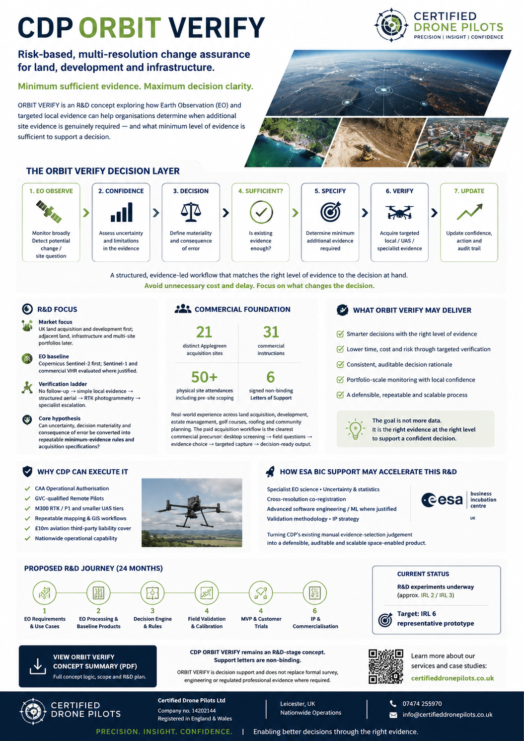
The ORBIT VERIFY approach
ORBIT VERIFY is being developed as a decision and assurance layer:
EO observation → confidence & uncertainty → decision relevance → evidence sufficiency → minimum additional evidence → targeted verification → updated confidence & action
Rather than automatically escalating to the highest-resolution or most expensive survey method, the R&D investigates whether uncertainty, decision materiality and the consequence of error can be translated into repeatable minimum-evidence rules and acquisition specifications.
This may result in no further acquisition at all, simple local evidence, structured aerial evidence, RTK photogrammetry, or escalation to an appropriate specialist where the decision requires it.
Built from real commercial experience
The concept has developed from CDP's existing experience supporting land acquisition, development and site-intelligence requirements.
Our commercial acquisition work includes:
21 distinct acquisition sites · 31 commercial instructions · 50+ physical site attendances including pre-site scoping
Across these projects, different questions have required different levels of evidence — from desktop and contextual assessment through ground-level and aerial imagery to higher-resolution RTK mapping.
ORBIT VERIFY aims to formalise and scale this evidence-selection judgement, using Earth Observation as an initial monitoring and screening layer.
Research & validation
Initial R&D is focused on UK land acquisition and development, with potential future applications across infrastructure and other multi-site portfolios.
The first EO baseline uses Copernicus Sentinel-2, with Sentinel-1 and commercial very-high-resolution imagery evaluated where justified.
Real-world validation environments include land acquisition, development, estate management, golf-course management, roofing and community planning contexts.
From operational capability to scalable product
CDP already operates commercial UAS and site-intelligence workflows supported by:
CAA Operational Authorisation · GVC-qualified Remote Pilots · RTK photogrammetry · GIS workflows · £10m aviation third-party liability cover
The next stage of R&D focuses on the areas required to turn existing manual evidence-selection judgement into a defensible, auditable and scalable space-enabled decision-support product, including EO science, uncertainty methodology, cross-resolution comparison, software engineering, validation and intellectual property strategy.
ESA BIC UK application
In August 2026, Certified Drone Pilots Ltd submitted CDP ORBIT VERIFY for consideration under the ESA Business Incubation Centre UK programme at Space Park Leicester.
The proposed incubation programme would investigate and validate the technical and commercial hypotheses behind ORBIT VERIFY through structured R&D, field validation and customer trials.
CDP ORBIT VERIFY remains an R&D-stage concept. Submission of an application does not imply endorsement, acceptance or affiliation with ESA or ESA BIC UK.